The Great Loop: A Great Lakes Captain's Reference Guide
A Great Lakes captain's reference guide to America's Great Loop — the route, the segments, the Lakes leg, and what most guides leave out.
I run a captain's service on the Detroit River, out of Grosse Ile, Michigan. Every summer, boats with white burgees flying from their bows come through Lake St. Clair and the Detroit River on their way somewhere — usually north toward Lake Huron, occasionally south through Lake Erie toward the Erie Canal. Those white burgees mean they're cruising America's Great Loop. The ones flying gold burgees have already finished it.
I've spent enough time on these waters to know which parts of the Loop most owners feel ready for and which parts make them quiet. The Great Lakes leg is almost always the quiet part. Every published guide treats the Atlantic Intracoastal Waterway in granular detail, walks you lock-by-lock through the inland rivers, and then summarizes the Great Lakes section as "transit Lake Erie, cross Lake Huron, head down Lake Michigan to Chicago." That is technically correct. It is also the part where the most preparation matters and where the fewest resources go deep.
This guide is meant to fill that gap. The first half is a straightforward reference to the full Great Loop — what it is, where it goes, how long it takes, what kind of boat you need. The second half is what I can offer that no published guide I've found does well: a working captain's perspective on the Great Lakes section, written from the wheelhouse rather than the marina office.
If you've never heard of the Great Loop, you'll know what it is by the end. If you're already planning yours, the parts you actually need will be in the Lakes section.
What is the Great Loop
The Great Loop is a continuous circumnavigation of the eastern United States and part of Canada by boat. The route covers a minimum of about 5,250 miles and stretches up to roughly 6,000 miles or more depending on which optional segments and side trips a boater chooses. It connects the Atlantic Intracoastal Waterway, the New York State Canals, the Great Lakes, the inland rivers (primarily the Illinois, Mississippi, Ohio, Tennessee, and Tennessee-Tombigbee waterways), and the Gulf of Mexico into a single loop. Most boats complete it in about a year, though it has been done in as little as twelve days by record-chasing professionals and in as long as twelve years by people doing it in segments.
The community is organized informally around the America's Great Loop Cruisers' Association (AGLCA), which has issued tens of thousands of memberships over its twenty-five-plus years. Boaters currently underway fly a white burgee; those who have crossed their own wake — completing the full loop — fly a gold one. Roughly 250 boats report a completion each year. It is not a casual undertaking, but it isn't reserved for professional mariners either. It has been completed in everything from a sixteen-foot johnboat to a hundred-foot motor yacht.
The default direction is counterclockwise, primarily so that boaters travel with the river currents on the Mississippi and connected inland rivers rather than against them. Counterclockwise also lines up well with the seasons: summer on the Great Lakes, fall down the rivers, winter in Florida, spring back up the East Coast. Clockwise has been done, but you're fighting current on the rivers and chasing a tighter weather window on the Lakes.
The Route in Brief
There is no single Great Loop. Every Looper makes a series of route choices depending on the boat's air draft, the owner's tolerance for big water, and personal interest. The basic structure is consistent, though, and I'll walk it counterclockwise from a notional starting point in Chicago.
Down the inland rivers. From Chicago, boats take either the Chicago River and Chicago Sanitary and Ship Canal or the Cal-Sag Channel to reach the Illinois River. The Illinois flows southwest through Joliet, Peoria, and Grafton, joining the Mississippi north of St. Louis. From here, most Loopers continue down the Mississippi only as far as the Ohio River at Cairo, Illinois, then go briefly upstream on the Ohio to reach the Cumberland or Tennessee Rivers and route south on the Tennessee-Tombigbee Waterway. The Tenn-Tom drops through a chain of locks into the Lower Tombigbee and eventually reaches Mobile, Alabama, on the Gulf of Mexico. The reason most boaters avoid the lower Mississippi all the way to New Orleans is straightforward: it is a working commercial river with heavy barge traffic, limited recreational marinas, and few easy fuel stops.
Across the Gulf. From Mobile, the Gulf Intracoastal Waterway runs east through Florida's panhandle. Loopers face a choice: hug the coast through the Big Bend (a longer but protected route) or make an overnight Gulf crossing from somewhere near Carrabelle, Florida, to Tarpon Springs or Clearwater on the peninsula's west side. The crossing saves significant time but requires a settled weather window and a boat that can handle open Gulf water for roughly twenty hours. (NOAA notes that the Loop route passes near several National Marine Sanctuaries on this segment and through Florida, including the Flower Garden Banks, the Florida Keys, and Gray's Reef — worthwhile side trips for boaters with time to spare.)
Around Florida. From Florida's west coast, Loopers either run south along the coast and around the Keys, or cut across the peninsula through the Okeechobee Waterway. The Okeechobee is faster and protected, but bridge heights restrict taller vessels. Either way, the route picks up the Atlantic Intracoastal Waterway and turns north.
Up the Atlantic ICW. The Atlantic Intracoastal Waterway runs north through Florida, Georgia, the Carolinas, and into the Chesapeake Bay. This is the most documented stretch of the Loop. There are endless guides, mile markers, marina directories, and trip reports. Most Loopers spend a relaxed two to three months on this leg.
Through the Chesapeake and up to New York. From the Chesapeake, boats run north through the C&D Canal into Delaware Bay, around Cape May, New Jersey, and then either up the New Jersey coast on the Atlantic or through a more protected inside route. Both meet in New York Harbor, where the Loop heads up the Hudson River to Waterford, New York.
The canal decision. At Waterford, the Loop offers its biggest single route choice. Boats can take the Erie Canal west across New York State, dropping into Lake Erie at Buffalo (provided their air draft can handle the western Erie Canal bridges, which are lower than the eastern section). Or they can take the Oswego Canal north into Lake Ontario, then either continue west to the Welland Canal and into Lake Erie, or cross into Canada and take the Trent-Severn Waterway through Ontario into Georgian Bay on Lake Huron. The Trent-Severn route is the more scenic of the two, takes longer, and requires a Canadian crossing.
The Great Lakes. Whichever route a Looper takes into the Lakes, every boat eventually transits Lake Huron, passes through the Straits of Mackinac between Michigan's Lower and Upper Peninsulas, and heads south down Lake Michigan to Chicago. From there, the loop closes back at the start of the inland river system.
That's the full circuit. About 6,000 miles, roughly fifteen states and the Canadian province of Ontario, more than a hundred locks, and most of a year if you're doing it on the traditional schedule.
The Great Lakes Leg: From the Wheelhouse
The Great Lakes section of the Loop runs from wherever a boat exits the New York Canal system to wherever it enters the Illinois River at Chicago. Depending on which canal a Looper took into the Lakes, that might mean traversing Lake Erie, the Detroit River, Lake St. Clair, the St. Clair River, Lake Huron, the Straits of Mackinac, and Lake Michigan — five lakes and three connecting waterways in a stretch that most published guides cover in a paragraph.
I cruise these waters professionally. Here is what actually matters.
Lake Erie
Lake Erie is the shallowest of the Great Lakes, and that shallowness is the single most important fact about cruising it. Shallow water builds steep, short-period waves quickly when wind opposes the lake's east-west axis. A Lake Erie that was glass at 7 a.m. can become genuinely punishing by mid-afternoon if the wind clocks westerly. The lake doesn't care that you have a schedule. Loopers crossing Lake Erie from Buffalo to the Detroit River or Lake Erie to Sandusky should plan around weather windows, not around calendar dates.
The good news: Lake Erie's southern shore has a dense chain of harbors — Erie, Pennsylvania; Ashtabula; Cleveland; Sandusky; Toledo. There is almost always a port of refuge within a few hours' run. The bad news: when conditions turn, those harbors are where every recreational boat heads at the same time. Reservations matter in season.
The north shore of Lake Erie (Port Dover, Port Stanley, Erieau, Leamington, Kingsville) is quieter and more relaxed, though most Loopers come down the south shore by default.
The Detroit River and Lake St. Clair
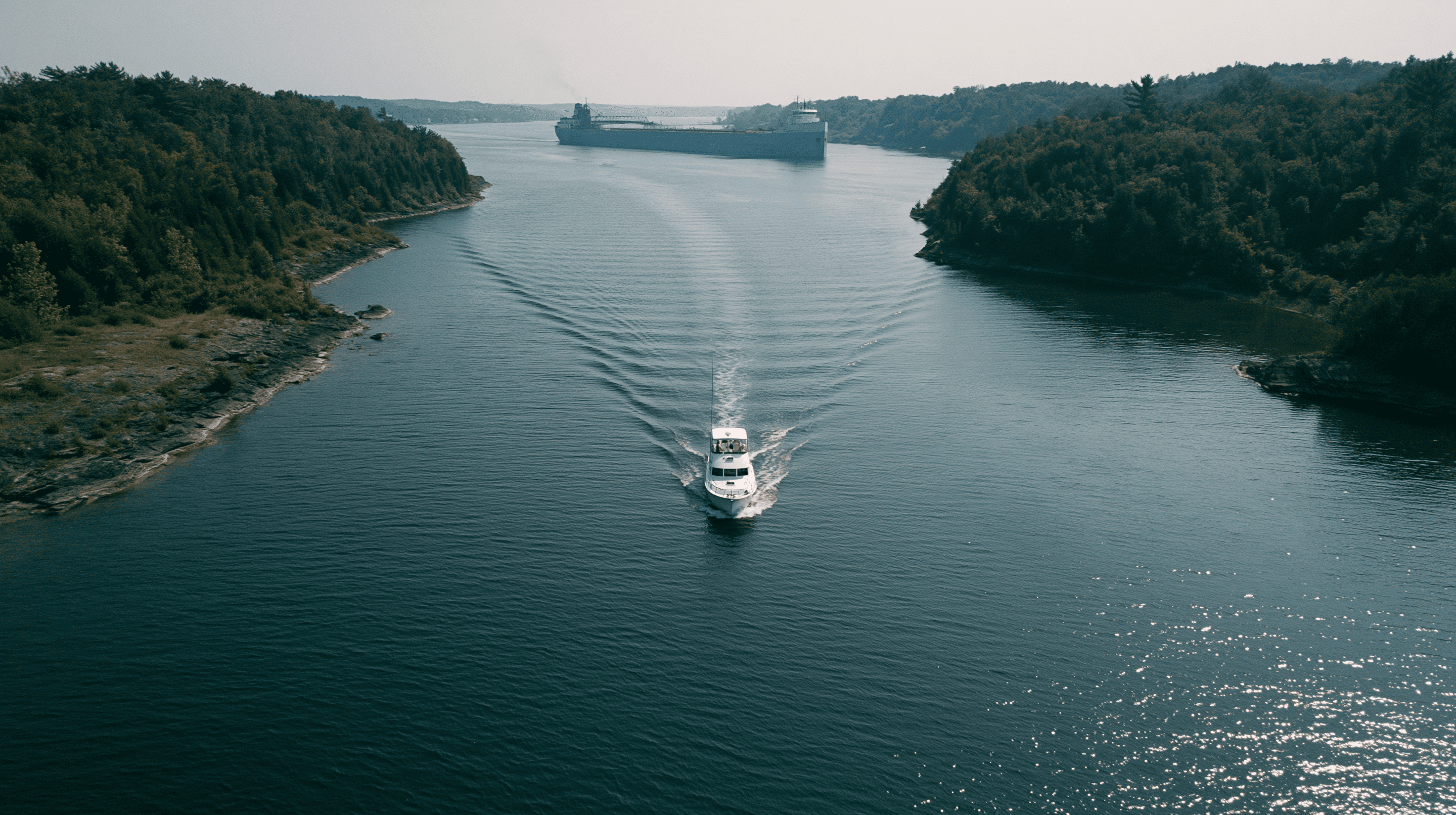
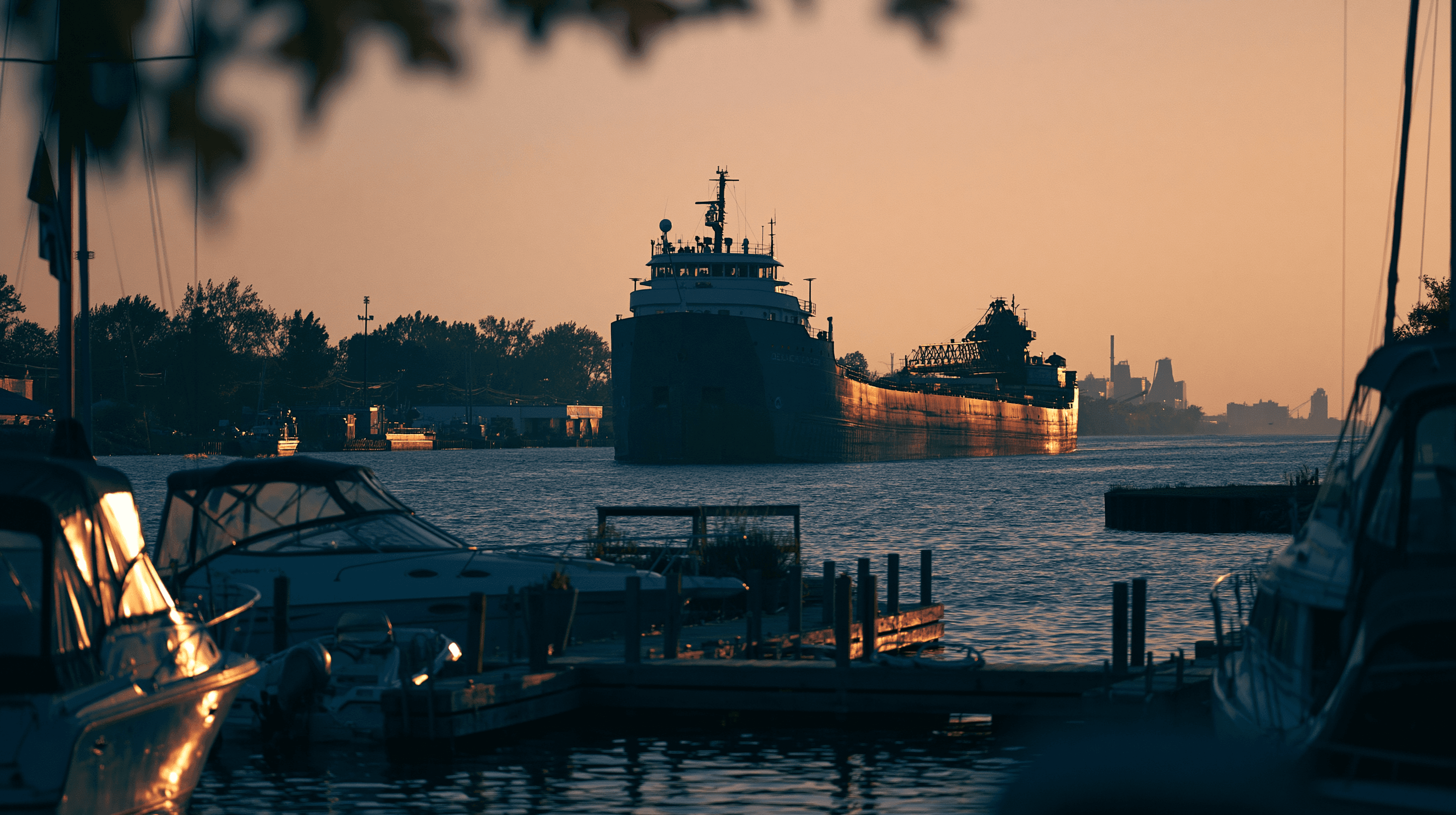
This is my home water. The Detroit River is a working commercial waterway. Lake freighters — the big 700-to-1,000-foot ore carriers — pass through here continuously during shipping season, and their wakes are not trivial. A loaded freighter pushes a displacement wave that can run two to three feet at the shoreline several minutes after the freighter has gone by. The first time you experience it, it is striking. The second time, you know to point your bow into it.
The river is navigable, well-marked, and not difficult to read. The main shipping channel runs down the center, and recreational traffic generally stays out of it except to cross. Grosse Ile sits in the middle of the lower river, splitting the Trenton Channel (US side, recreational) from the Amherstburg Channel (the main commercial route through Canadian waters). Loopers heading north typically take the eastern side past Belle Isle and into Lake St. Clair.
Lake St. Clair is a shallow, mostly featureless body of water about twenty-six miles across. It has a single dredged channel — the South Channel — that carries the commercial traffic across. Outside the channel, depths are often less than ten feet, sometimes much less. Loopers should stay in or near the channel unless they know the lake's bottom intimately.
The St. Clair River, on the lake's north end, runs about forty miles between Lake St. Clair and Lake Huron. It has a strong downstream current — typically two to three knots — and carries heavy commercial traffic. Going north against the current, fuel burn matters. Going south with it, boat handling matters.
Lake Huron
Lake Huron is the underrated lake. Loopers who take the Trent-Severn Waterway into Georgian Bay experience some of the most beautiful cruising on the Loop — the North Channel and the 30,000 Islands region are world-class. Loopers who come up the St. Clair River from Detroit see less of this but still get a substantial transit across the lake's western side toward Mackinac.
Huron is deeper than Erie and behaves differently. Waves take longer to build but also take longer to lay down. A blow that puts steep four-foot chop on Erie within hours might put long six-to-eight-foot rollers on Huron for a day after the wind dies. The lake is also bigger and offers fewer ports of refuge on its western shore between Port Huron and Mackinaw City. Saginaw Bay is a notable detour east; Tawas, Harrisville, Alpena, and Rogers City are the practical refuges along the way north.
The Canadian side, accessible via the North Channel or via crossing from Mackinac, is some of the finest cruising water on the continent. If a Looper has any flexibility in the schedule, the North Channel earns it.
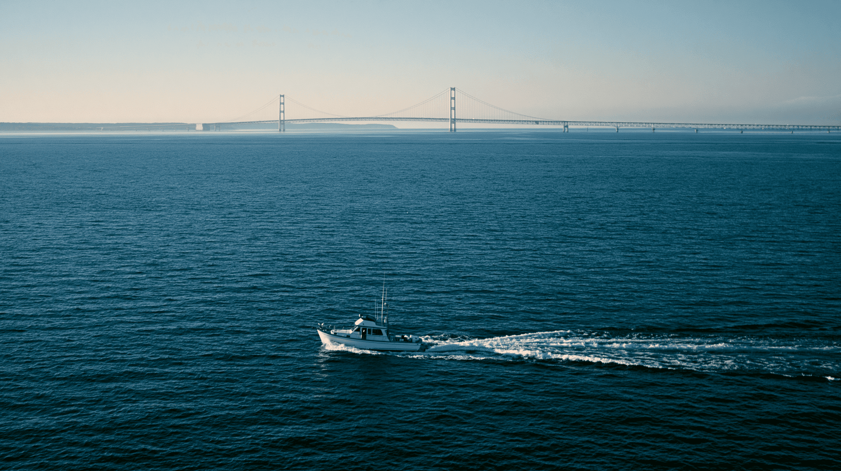
The Straits of Mackinac
Every Loop boat passes through the Straits of Mackinac, the five-mile-wide passage between Michigan's Lower and Upper Peninsulas that separates Lake Huron from Lake Michigan. The Straits are crossed by the Mackinac Bridge — a suspension bridge with vertical clearance well above any Loop boat's air draft — and they host two major harbors: Mackinaw City on the south shore and St. Ignace on the north. Mackinac Island, three miles east, is the cultural and commercial center of the area.
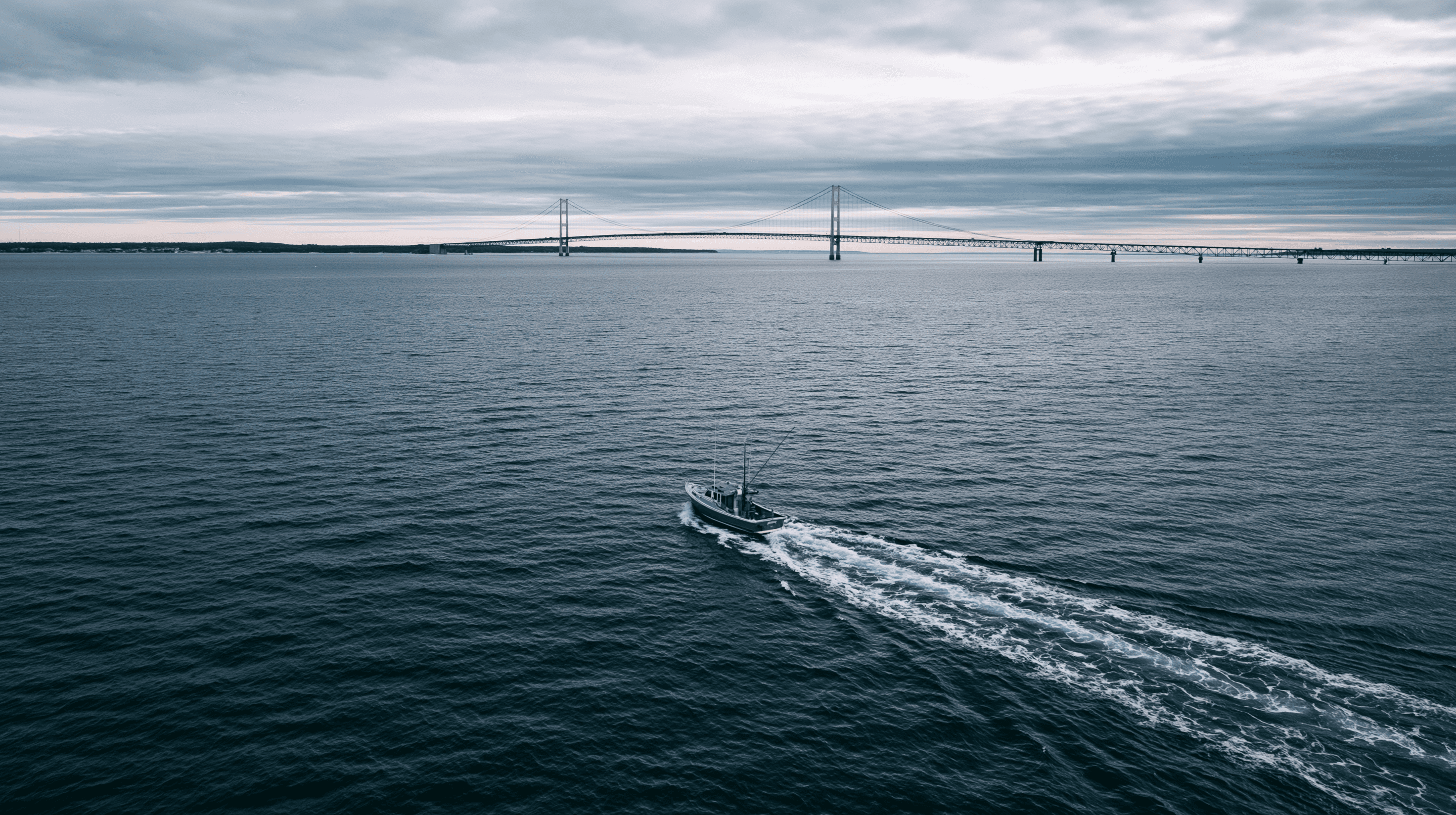
The Straits funnel weather. A westerly that the open Lakes shrug off can accelerate to twenty-plus knots through the gap. Current also moves through the Straits, depending on lake levels and barometric pressure. None of this is dangerous in a properly prepared boat in reasonable weather, but it is worth knowing about before the crossing rather than during it.
The Soo Locks and Lake Superior (Optional)
A common side trip from the Straits is north to Sault Ste. Marie, where the Soo Locks lift vessels from Lake Huron up to Lake Superior. The Soos are American locks operated free of charge by the Army Corps of Engineers (the Canadian Sault lock is also available, smaller, and oriented to recreational traffic). Lake Superior is colder, deeper, less developed, and more remote than the other Lakes. Loopers who add Superior to their itinerary do so for the wilderness — Pictured Rocks, Isle Royale, the Apostle Islands — and the lake is large enough that even a brief visit is a significant detour.
This is genuinely optional. Most Loopers skip Superior and head straight down Lake Michigan from Mackinac. The boaters who do detour rarely regret it.
Lake Michigan
Lake Michigan runs north-south for over 300 miles, which makes it the longest single stretch of open water on the Loop. Loopers must choose between the Michigan shore (eastern side, more developed, more harbors of refuge, deeper draft) and the Wisconsin shore (western side, fewer big-city stops, beautiful Door County and the islands at the lake's northern end). Both work. The Michigan shore offers Mackinaw City, Petoskey, Charlevoix, Traverse City, Frankfort, Manistee, Ludington, Pentwater, Muskegon, Grand Haven, Holland, Saugatuck, South Haven, St. Joseph, and finally Michigan City and Chicago — a port roughly every twenty to forty miles. The Wisconsin side has more open stretches.
Lake Michigan is open water. With several hundred miles of north-south fetch, conditions can build substantially. Most Loopers run the eastern shore in short legs, planning each day's run with the wind forecast in hand.
The Erie Canal vs. Trent-Severn Decision
If there is one route choice that defines a Looper's Great Lakes experience, it is the choice at Waterford, New York. The Erie Canal runs west across New York to Buffalo and drops boaters into Lake Erie, which then leads through the Detroit River and Lake St. Clair into Lake Huron. The Trent-Severn Waterway runs north through Canada and emerges in Georgian Bay on Lake Huron, bypassing Lake Erie and the Detroit corridor entirely.
The Trent-Severn is more scenic, more relaxed, has more locks (forty-four versus the Erie's thirty-five), takes longer, and requires a passport and Canadian customs clearance. The Erie Canal is more direct, more developed, includes a stretch through Lake Erie that some boaters love and others want to be done with, and lets boats reach Lake Huron via the Detroit River.
Air draft can force the decision. The western Erie Canal has fixed bridges with clearances that exclude taller vessels. The Trent-Severn has its own air-draft constraints but allows different boats through.
I'm biased — boats coming through my home waters on the Detroit River chose the Erie. But I've also coached owners who came down through the Trent-Severn route and felt it was the highlight of their trip. There is no wrong answer.
Is Your Boat Right for the Loop
Three numbers define whether a given boat can run the Great Loop without major detours.
Air draft: 19'6". The lowest fixed bridge on the standard Loop route is on the Illinois Waterway, and it cannot be bypassed. A boat with an air draft higher than 19'6" cannot complete the Loop on the conventional path. Some Loopers with taller boats have unstepped masts, removed antennas, or lowered radar arches; for many vessels this is a real engineering project rather than a checkbox.
Water draft: 5'. A draft over five feet starts to limit which marinas a boat can enter and which side channels remain available. Loopers with deeper drafts can still complete the route, but they will find themselves staying in the main shipping channels rather than tucking into smaller harbors.
Seaworthiness. The Great Loop is described as a "high-adventure, low-risk" route, and that characterization is fair as long as the boat is genuinely seaworthy. There are open-water segments — the Gulf crossing, the Lakes, parts of the Atlantic and the Chesapeake — where conditions can build well beyond what a protected-waters cruiser was designed for. A boat that is honestly suited to the Lakes will handle most of the Loop's other open-water sections; the reverse is not always true.
The Loop has been completed in trawlers from twenty-five to seventy feet, in motor yachts, in express cruisers, in sportfishers, in catamarans, and in a single inflatable. The right boat is the one the owner knows well, can maintain underway, and can run for a full season without exhausting the crew.
Time, Money, and Direction
Most Loopers complete the route in about a year. The traditional schedule has boats on the Great Lakes in summer, on the inland rivers in fall, in Florida and the Gulf for winter, and on the Atlantic ICW heading north in spring. About 250 boats report a completion each year, and roughly the same number are partway through at any given time.
Costs vary dramatically. The Loop has been completed on a tight budget by self-sufficient cruisers and as a six-figure-a-year proposition by boaters who marina-hop every night and eat ashore. Fuel is the largest single variable, followed by dockage. Loopers who anchor out, cook on board, and run efficient diesels at trawler speeds can complete the Loop for a fraction of what a triple-engine express cruiser running at thirty knots will spend. Neither is wrong; they're different trips.
A growing number of Loopers complete the route in segments rather than continuously — cruising for a season, returning home for the off-season, and rejoining the boat the following year. This works well for owners who can't commit to a full year off but want to make the journey. The boat winters wherever it stops; the next season picks up there.
Insurance and the Hired Captain
Marine insurance becomes meaningful on a trip like the Great Loop in ways it doesn't for weekend cruising. Most policies have navigation limits — explicit clauses that define which waters the boat is covered in. A policy written for Lake St. Clair day-trips may not cover the same boat on the Gulf of Mexico or the lower Mississippi. Loopers should review the policy's navigation limits with their carrier well before departure and request a written extension if needed.
Boats hired for delivery — for instance, an owner who flies home for a month and engages a professional captain to move the boat the next leg — require additional consideration. Most insurance carriers will cover a hired captain provided they receive the captain's credentials in advance and issue a policy rider or endorsement. The rider names the captain, references the USCG Mariner Reference Number, and adds the captain to the policy for the specified voyage. Without this rider, an incident under the hired captain's watch may not be covered. I've written separately about what insurance carriers actually need to issue a rider for a hired captain.
For owners who hire a captain only for the Great Lakes leg — which I see often — the rider is typically straightforward. The carrier needs the captain's license documentation, the Mariner Reference Number, and the route and dates. It can be arranged in a few business days when the paperwork is complete on both sides.
When People Hire a Captain on the Loop
There are three patterns I see most often.
Pre-trip coaching. Owners who have bought a larger boat to make the Loop frequently hire a captain for several days of intensive on-water work before they depart. This isn't a delivery — it's training. We cover docking in unfamiliar conditions, handling currents (most Loop boats will encounter river current somewhere), anchoring properly, marine radio etiquette for locks and bridges, and emergency procedures. A few days of focused coaching in the spring can change how the entire season feels.
Segment delivery. Some owners do part of the Loop themselves and hire a captain for the segments they don't want to run — most commonly the inland rivers (the locks make some owners nervous) or the Great Lakes (the open water makes others nervous). I cover the Great Lakes from Lake Erie to Lake Huron and west to the Straits of Mackinac. Other captains specialize in the rivers, the ICW, or the Gulf. Loopers often piece together a delivery network across the year.
Emergency assistance. Things happen. Owners have medical events, family situations, or unexpected obligations that force them off the boat midway through a season. A captain can take the boat to a safe winter mooring, or all the way home if needed. This is unplanned by definition, but it happens often enough that it's worth knowing in advance who you'd call.
A coached owner is a confident owner, and a confident owner enjoys the trip far more. If you want to talk through what coaching looks like for your boat and your route, reach out and we'll set up a call. If a delivery is what you need, the vessel delivery page covers how that works.
A Note from the Helm
The Great Loop is one of the genuinely remarkable journeys a boat owner can undertake. Six thousand miles, fifteen states, two countries, four seasons, dozens of small towns most people have never heard of, and a handful of major cities seen from the water rather than from a highway. The Looper community is generous with information, well-organized through AGLCA, and quick to help a newcomer.
It is also a year of seamanship in compressed form. Every type of water you can run in eastern North America short of the open ocean appears somewhere on the Loop. The boaters who finish it — the gold burgee crowd — are better mariners than when they started by a noticeable margin. That's the part nobody really tells you about in advance. The trip changes you.
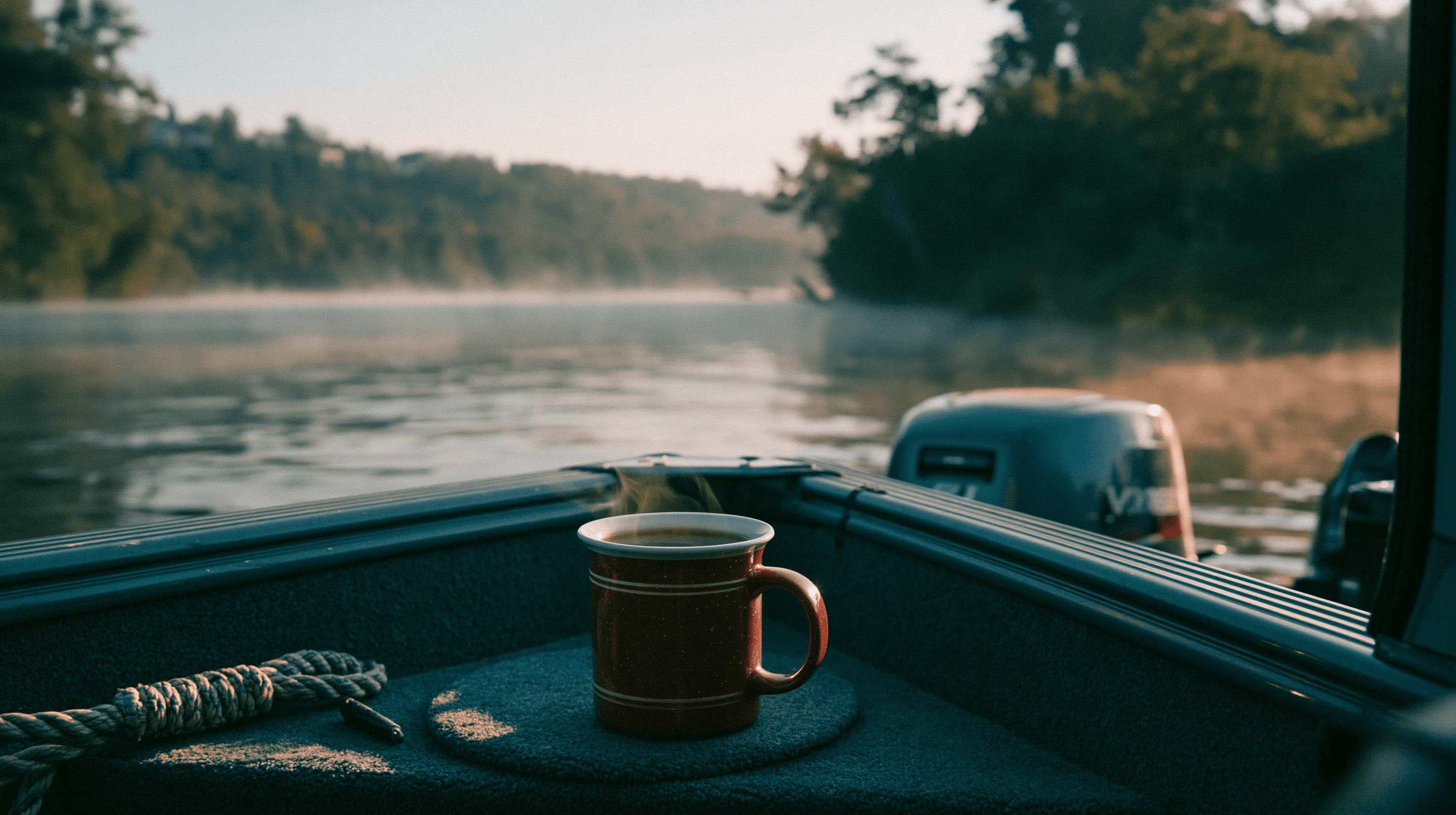
If you're planning yours and you'll come through the Great Lakes, you'll likely pass within a few miles of my home dock. Stop by. I'll buy you a coffee and tell you what the weather is going to do.
— Captain Tom


