What the St. Clair River Asks of Boat Owners
It's the fastest, busiest stretch of water in the whole chain, and the head of the river off Port Huron is where it asks the most of you. Here's what to know before you run it.

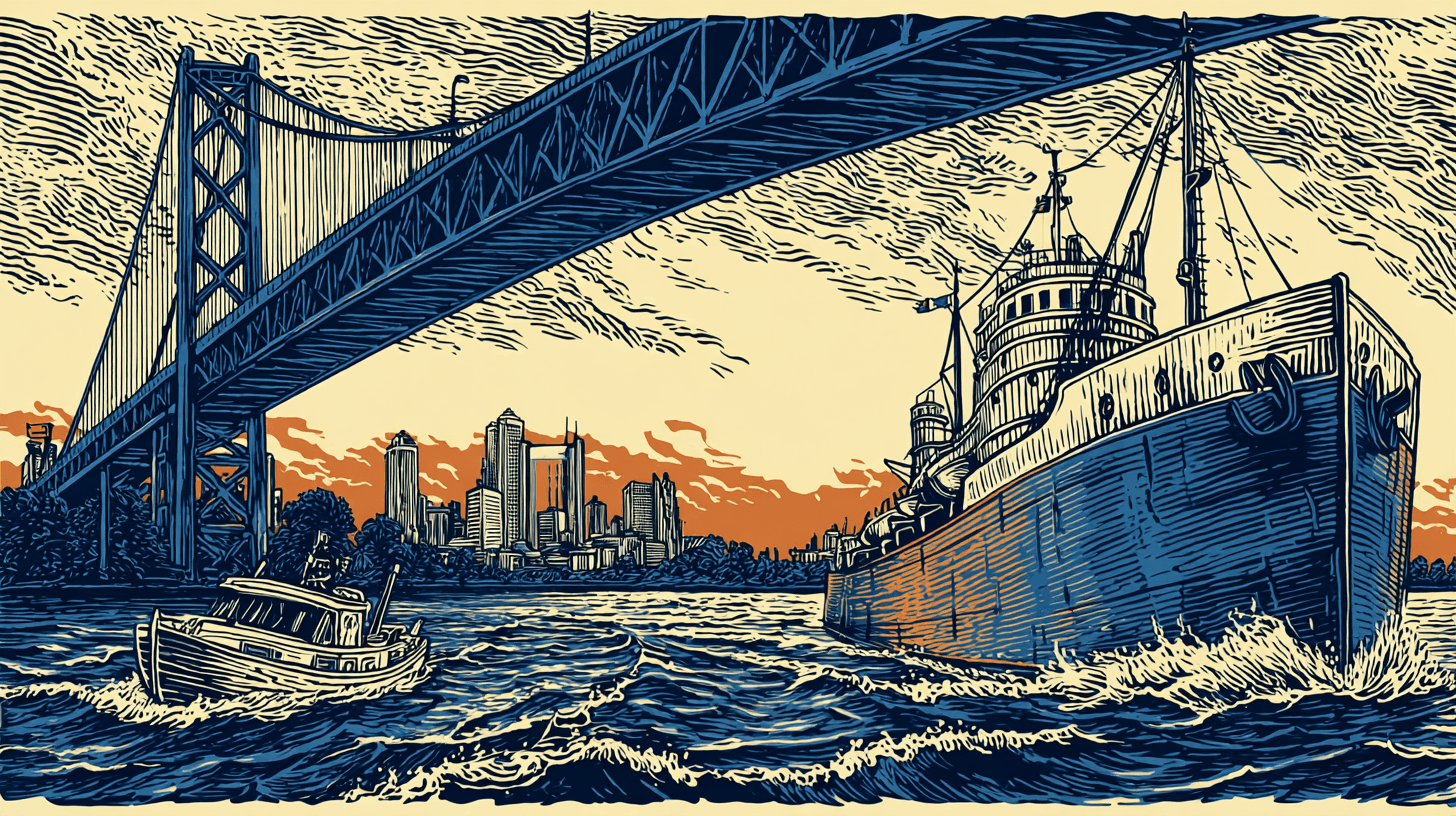
The first time a lot of boaters really feel the St. Clair River is at the top of it, under the Blue Water Bridge. They've run down from Lake Huron, the bridge is overhead, and suddenly the boat isn't doing what the throttle says it should. The current has them. Upbound boats crab toward the Canadian shore, downbound boats feel themselves being shoved along faster than they meant to go, and a helmsman who was relaxed thirty seconds ago is now paying very close attention.
That's the river introducing itself. It does that.
I've run the St. Clair more times than I can count, in both directions and in all kinds of conditions, and I'll tell you up front: it's my favorite stretch of this whole system to run, and it's also the one I respect the most. It connects Lake Huron down to Lake St. Clair, it's the fastest water in the chain, and it packs more commercial traffic into less room than anywhere else you'll boat around here. Here's what it actually asks of you.
It Asks You to Respect a Real Current
This is the big one, and it's the thing that separates the St. Clair from the Detroit River at the other end of Lake St. Clair. Both rivers have current. The St. Clair has more of it.
The whole Great Lakes system is downhill from Lake Huron, and the St. Clair River is where a good chunk of that drop happens. Going from Lake Erie up to Lake Huron means climbing roughly eight feet of elevation, and the upbound boater pays for every foot of it by breasting swift current the whole way. The current runs strongest at the head of the river: according to NOAA's Coast Pilot, boaters should expect around four miles per hour or more for the first mile below the Blue Water Bridge, and upbound vessels get pushed toward the west — the Michigan side — in that reach.
What this means in practice:
Going up (north, toward Lake Huron), the current is against you. Your speed over ground will be well below your speed through the water, and a small auxiliary or a low-powered boat can find itself crawling. The old-timers will tell you about taking the better part of a day to get a small sailboat from the Clinton River up to Port Huron, fighting current the whole way. Plan your fuel and your timing around a slower run than the distance suggests.
Going down (south, toward Lake St. Clair), the current is with you. That sounds easy, and it's the part that catches people. You're moving faster over the ground than your instruments suggest, your stopping distance is longer, and your turns happen quicker than you expect. Downbound is when people get sloppy, and downbound on a fast river is exactly when you don't want to.
The current doesn't steer the boat for you. It sets you. Upbound at the head of the river, that west set toward the Michigan shore is real, and you correct for it continuously, the same way you'd correct for a crosswind. Point the bow where the chartplotter track tells you the boat is actually going, not where the bow is aimed.
The river also gives you a free education in how current and wind interact. A north wind blowing against a south-running current stacks up a short, steep chop in a hurry, and the head of the river by Port Huron is where you'll feel it first.
It Asks You to Treat It Like the Working Channel It Is
The St. Clair is a major commercial shipping route, full stop. It's one of the busiest stretches of the Great Lakes Waterway, and the freighters that run it are the same 700-plus-foot lakers you'd see crossing Lake St. Clair or running the Detroit River — except here they're doing it in a narrower river, often while breasting the same current you are.
The rules don't change from what they are anywhere else on the system, but the stakes are higher because the room is tighter:
Give them the channel. A freighter in the St. Clair is constrained to the deep water and fighting current. It cannot maneuver around you. You are the one with options, every time.
Watch for the squeeze under the bridge. The head of the river by the Blue Water Bridge is where the current is fastest and the big ships and the recreational traffic are most concentrated at the same time. That's a spot to have your head up, your speed sensible, and your plan made before you get there, not while you're in it.
Mind the wake and the suction. A laker's wake on a confined river reaches the banks and bounces back, so the water stays disturbed after the ship passes. And never run close alongside a moving freighter's hull. A big vessel underway pulls water with it and can suck a small boat right into its side. Stay well off.
There are ferries, too. Cross-river ferries run between the Michigan and Ontario sides. They're marked on the charts, they cross when you may not expect them, and they get the same caution you'd give any working vessel.
A note on the Blue Water Bridge: It looks like it might be a concern for air draft, sitting there over the river. It isn't, for any recreational boat. The bridge clears roughly 150 feet over the water. It's a fixed crossing, not a drawbridge, so there's nothing to signal and nothing to wait for. The thing under the bridge that demands your attention is the current and the traffic, not the steel overhead.
It Asks You to Know the Delta Before You Get There
The bottom end of the St. Clair is where it gets interesting in a different way. As the river empties into the northeast corner of Lake St. Clair, it fans out into the largest delta in the Great Lakes system — a spread of marsh, islands, and multiple channels known as the St. Clair Flats. The river splits into the North, Middle, and South Channels, with smaller cuts branching off through the flats.
For most recreational boaters running the main route, the South Channel is the through-route into Lake St. Clair, and it's well marked. But the delta is a place to be deliberate:
Stay in the marked channel. The water outside the channels in the flats goes shallow and weedy fast, and there's rock and rip-rap along some channel edges that sits just under the surface. This is buoy-to-buoy country. Know your Red Right Returning and hold the line between the marks.
Some of the smaller channels have opening bridges. The main South Channel route is clear, but if you wander into the secondary channels through the flats, you'll meet bascule and swing bridges that have to open for you. The signal to request an opening is set by federal regulation: one prolonged blast followed by one short blast, and if the bridge can't open right away the tender answers with five short blasts, meaning stand by. Most boaters now raise the bridge tender on the VHF instead, which is cleaner — and worth knowing your radio procedure before you need it.
It's a customs border. The Canadian side of the river and parts of the delta are Ontario. If you cross into Canadian waters and stop, dock, or anchor, you're subject to Canadian customs and border rules. Know where the line is and what your obligations are before you go.
It Asks You to Plan the Run, Not Just Make It
Because the current is real and one-directional, the St. Clair rewards a little planning more than most water around here.
Decide your direction's reality before you leave. Upbound, build in extra time and extra fuel for a slow fight against the current. Downbound, plan for a faster run and a longer stopping distance, and don't let the easy ride lull you. Either way, know where your bailout harbors and marinas are — Port Huron at the top, the towns of Marine City and St. Clair partway down, Algonac near the delta — so you've got a plan if weather or a mechanical issue puts you in a spot you didn't choose. That's the same trip-planning discipline that matters whether you're running this river or crossing Lake Huron at the top of it: the captains who don't get caught out are the ones who decided where they'd duck in before they needed to.
The River Is Worth It
None of this is meant to scare anyone off. The St. Clair is a genuinely great river to run. The towns along it are some of the best little boating stops in the region, the water is clean and deep down the main channel, and there's something about running under the Blue Water Bridge with Lake Huron opening up ahead of you that doesn't get old.
The current and the traffic aren't reasons to avoid the river. They're just the river's terms. Respect the current, give the freighters their room, stay in the channel through the delta, and plan your run around the direction you're going, and the St. Clair will be one of the best stretches of water you run all season.
If you're new to the river, or you've moved up to a boat that handles differently in a current than the one you learned on, that's exactly the kind of thing a few hours of on-water coaching sorts out fast — running the head of the river with someone aboard who's done it a hundred times takes the mystery out of it. And if you've got a boat that needs to get up or down the river and you'd rather hand the run to a professional, that's a conversation worth having.