Okeechobee Waterway Crossing: Lake Level, Locks and Bridges
The lake sets your depth, a railroad bridge sets your height and the locks keep daytime hours. In 2027, two of the locks close in turn, January to April.

An Okeechobee Waterway crossing is settled before you cast off, by three numbers: the level of Lake Okeechobee, the height of your boat and the hours the locks keep. Get them right and it's the short way across Florida: 154 miles by the Corps of Engineers' count, from the ICW at Stuart to the Gulf past Fort Myers, through five locks and one big, shallow lake.
This winter there's a fourth number, and it's a date. The Corps has scheduled two of the five locks for major maintenance, one after the other, and from Jan. 4 to April 30, 2027, the waterway is closed to through traffic.
The 2027 lock closures
W.P. Franklin Lock, east of Fort Myers: closed to all traffic Jan. 4 to March 1
Ortona Lock, east of LaBelle: closed to all traffic March 1 to April 30
While one is closed, the other is open to local traffic only
To cross before the work starts, be through both by the last lockage on Jan. 3
The route
From the ICW in St. Lucie Inlet, the waterway runs up the St. Lucie River past Stuart and through the St. Lucie Canal to the lake at Port Mayaca. It crosses the south end of Lake Okeechobee, leaves it at Moore Haven, and follows the Caloosahatchee down to Fort Myers and San Carlos Bay. NOAA's Coast Pilot counts the miles west from zero at the inlet, and it warns of cross-currents at that first turn off the ICW, so allow for the set.
The St. Lucie Lock, at Mile 15.1, makes the biggest lift, about 14 feet from sea level up to the canal. The other four sit at Port Mayaca, where the canal meets the lake; at Moore Haven, Mile 78.0, where the lock was renamed for Julian Keen Jr. in 2021; at Ortona, Mile 93.5; and at W.P. Franklin, Mile 121.4.
The markers carry the ICW's yellow triangles and squares. Westbound, keep the triangles to starboard and the squares to port, whatever color the marker is. Eastbound, reverse it. I go through the rest of Florida's differences in what changes at the helm in Florida.
The lake sets your depth
From the St. Lucie Lock to Moore Haven, chart depths are measured from a water level of 12.56 feet, the Coast Pilot says. The Corps holds the St. Lucie Canal above that, but the lake rises and falls, and below 12.56 you have less water out there than the chart shows. The Corps' daily Lake Okeechobee report had the lake at 12.16 feet on Oct. 7, 2026, against 13.68 a year earlier and 15.57 the year before.
The same report does the arithmetic: a navigation depth for each route across the lake, plus a bridge clearance that works out to the railroad bridge at Port Mayaca. That day it put Route 1 at 6.1 feet and Route 2 at 4.3, against the 8 and 6 feet the channel was built for. Plan on the report's numbers, with a margin, since the Corps works them out from channel surveys made in 2007 and 2008. Check them against your draft when you pick the dates and again the morning you leave. Each lock also posts a gauge with the day's depth.
Route 1 or Route 2
At Port Mayaca you pick a route across the lake. Route 1 crosses open water, southwest to a marked channel through Rocky Reef and then west to Clewiston. Route 2 follows the south shore beside the levee, marked by daybeacons, and runs longer: the Corps puts Port Mayaca to the Moore Haven lock at 39 miles by Route 1 and 50 by Route 2.
The Coast Pilot calls Route 2 the route most used and recommends it when the lake is rough and the wind is up. The lake is 22 to 30 miles across and only 10 to 14 feet deep in the middle, by the Coast Pilot's figures, and shallow water that wide stands up in a hurry. Anyone who has crossed Lake Erie in a fresh breeze knows the feeling. Route 2 is also the shallower route, though: 4.3 feet against Route 1's 6.1 on Oct. 7, so it has to suit your draft before it can suit the weather.
From Oct. 12 to Dec. 22, 2026, Route 2 is out for most boats anyway. Its only bridge, the Torry Island swing bridge at Belle Glade, won't open, and a work platform under it cuts the clearance to 8 feet. That makes this fall's crossings a Route 1 job for a light-wind day. I'd rather wait a day on the near side of the lake than cross it in a blow.
Locks keep daytime hours
The five locks run 7 a.m. to 5 p.m., with the last lockage starting at 4:30. Go by the Corps' hours, not the Coast Pilot's, which still lists 6 a.m. to 9:30 p.m. Call the lock on VHF channel 13 (the bridges answer on 9), and plan on 15 to 20 minutes a lockage.
The lock operator runs the show from the approach on, and the Corps has its operators require everyone aboard to wear a Coast Guard-approved life jacket and shut the engines off. Hang fenders on both sides until you know which wall you'll get. The Corps' locking guidance says to carry at least two lines, each at least 75 feet long, and to tend them, never tie them off. The boat goes up or down with the water, and the lines have to go with her.
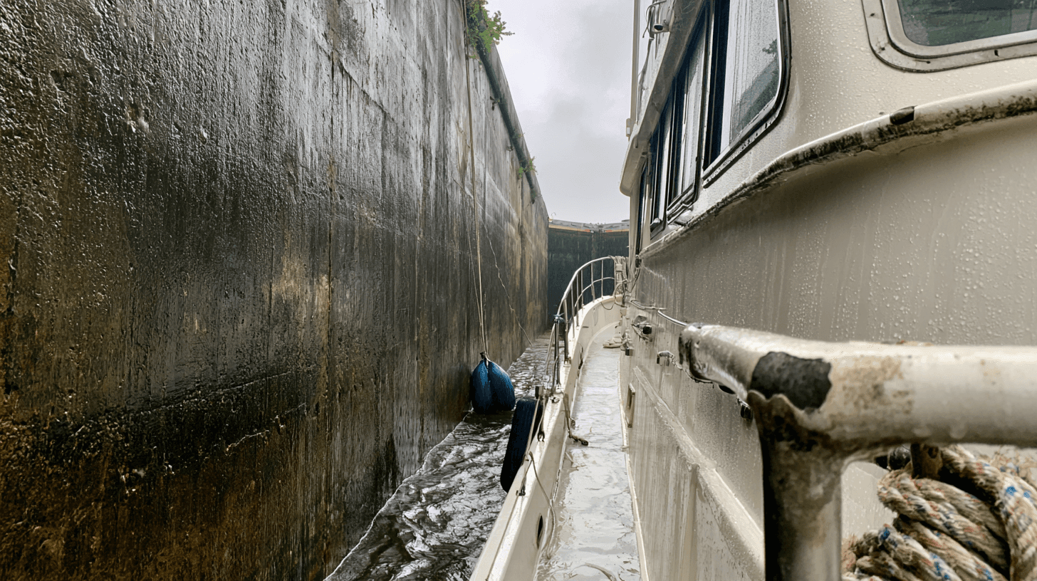
When the Corps is letting water out of the lake, the approaches get lively. The Coast Pilot warns of strong current east of the St. Lucie Lock, where the released water funnels through the bridges, and tells boats at Moore Haven to hold at the standby areas until a discharge stops. If the lock tells you to wait, wait.
Changes go up as Notices to Navigation, so read them before you go. Since Sept. 29, 2026, for one, the Corps has warned of intermittent closures at the St. Lucie Lock while it works on the lock's manatee protection system.
Bridges and your boat's height
The lowest clearance on the route is the railroad lift bridge about a mile east of the Port Mayaca Lock, at Mile 38.0: 49 feet when it's up, at the canal's normal level. It stays up between trains, and the daily lake report gives its clearance that day (49.44 feet on Oct. 7). On the chart, every fixed bridge and power line on the route clears more than that. Measure to the top of the highest antenna. If she's taller than 49 feet, she goes around.
One exception needs checking. In June 2026 the Corps posted a notice about a fiber-optic cable hanging about 11 feet over the St. Lucie Canal, half a mile west of the Indiantown highway bridge, with no repair date. Before you plan a crossing, ask the Corps' Clewiston office (863-983-8101) whether it's been fixed.
West of Moore Haven, the highway drawbridges at LaBelle, Denaud, Alva and Olga open on signal, with three hours' notice from 10 p.m. to 6 a.m. Denaud's swing bridge clears only 9 feet closed. Four bridges have rules of their own:
Stuart's railroad bridge, Mile 7.4, stays open except for trains, and when trains keep it down, the federal bridge rules still have it open for 10 minutes at the top of every hour from 6 a.m. to 8 p.m. The Dixie Highway drawbridge beside it won't open while the railroad bridge is down.
The railroad bridge at Indiantown, Mile 28.2, stays open from 7 a.m. to 7 p.m. between trains. Overnight it needs three hours' notice.
The railroad bridge just past the Moore Haven lock takes about 15 minutes to swing, the Coast Pilot says, so westbound boats should call for it from inside the lock.
LaBelle's highway bridge, Mile 103, clears 28 feet closed, and it won't open from 7 to 9 a.m. or 4 to 6 p.m. on weekdays.
How long it takes
Most boats cross in two or three days. By Route 1, Stuart to Clewiston is about 58 miles with two locks, and Clewiston to Fort Myers about 70 with three. That's two full days at trawler speed, and a late start or a long wait at a lock makes it three. (The rest of the Corps' 154 miles is the 7 from the inlet up to Stuart and about 20 from Fort Myers down to the Gulf.) Clewiston, Moore Haven and LaBelle all have places to tie up if the day runs short, and I'd keep a spare day in hand for the lake.
Who crosses here
A Great Lakes boat wintering in Florida on the Gulf side crosses here from the ICW and comes back the same way in the spring. Loop boats meet it from the other end, after the Big Bend and the run down the Gulf coast, then cross east to run north on the ICW. The Great Loop guide covers the rest of that route.
This winter, both run into the closure. To cross in either direction, a boat needs to be through Ortona and W.P. Franklin by the last lockage on Jan. 3. After that she goes around through the Keys or waits for the work to finish at the end of April, and a boat wintering on the Gulf side meets the same closure if she heads back before May, as a mid-April start north would. The Corps calls the dates expected, so check its notices before you plan around them.
A captain for the crossing
I run boats across the state on the Okeechobee as part of my boat delivery in Florida work, and owners who want to learn the locks and the lake can come along on an owner-assisted delivery. It makes a good first long run on a new boat. With two locks closing in January, a crossing this season wants dates settled before the holidays. A quick call sorts out most of it.
Keep Reading


FROM THE HELM
New articles, straight to your inbox.
A short note whenever a new piece goes up — seamanship, ownership, and lessons from the water. No spam, unsubscribe anytime.